🧭 What’s New: Nationwide Fault Mapping
- The Minerals and Geoscience Department (JMG) of Malaysia has identified and mapped 11 active earthquake fault zones nationwide, according to Johari Abdul Ghani, the country’s Plantation and Commodities Minister.
- The mapping was carried out between 2016 and 2020.
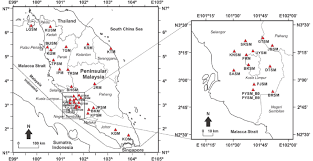
- Of those 11, six are in Peninsular Malaysia, and the rest are in East Malaysia (Sabah and Sarawak).
Peninsular Malaysia — 6 fault zones:
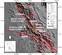
- Bukit Tinggi Fault (Pahang)
- Bokbak Fault (Kedah–Perak)
- Terengganu Fault (Terengganu)
- Banding Fault (Perak)
- Kuala Pilah Fault (Negeri Sembilan)
- Mersing Fault (Johor)
East Malaysia — Sabah & Sarawak:
- Tubau Fault (Miri, Sarawak)
- In Sabah: Lobou Lobou Fault and Mensaban Fault (Ranau), plus Lahad Datu Fault and Tabin Fault (Lahad Datu)
📡 Monitoring & Preparedness: What Malaysia Is Doing
- In Sabah alone, six active “fault-movement benchmark” stations have been installed to monitor subtle ground shifts.
- Across other states (Pahang, Selangor, Perak, Negeri Sembilan, Sarawak and Sabah), 47 passive monitoring stations are already operational, with plans to expand coverage to other high-risk areas including Johor.
- Regarding early-warning systems: MetMalaysia currently runs about 80 seismographic stations nationwide, supported by 323 international monitoring stations.
- Malaysia issues earthquake alerts within 8 minutes for quakes of magnitude 3.0 or higher, and under the 13th Malaysia Plan, aims to reduce alert time to 6 minutes by 2026.
Johari emphasized that seismic hazard maps are given to local authorities and engineers, who are advised to follow the country’s guidelines — the Malaysia National Annex to Eurocode 8 — when designing earthquake-resistant buildings.
🌍 Why This Matters — Malaysia is Not Immune
For a long time, many people assumed that countries like Malaysia — far from the so-called “Ring of Fire” — are largely safe from significant earthquakes. That belief may now be shifting.
- The identification of 11 active fault zones nationwide changes that perception: seismic risk — even if moderate compared to global hotspots — exists in both Peninsular and East Malaysia.
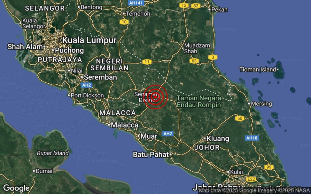
- Several states already flagged as “earthquake-risk areas” by JMG include Pahang, Terengganu, Perak, Negeri Sembilan, Sabah, and Sarawak.
- In recent months, government reports also identified 14 earthquake “hotspots” across the country — overlapping with many of these fault zones.
This mapping and monitoring initiative — combined with hazard-mapping, monitoring stations, and building code recommendations — suggests that Malaysia is transitioning from “low-earthquake awareness” to “earthquake resilience planning.”
🏗️ What It Means for Engineers, Builders, and Residents
Because of these developments:
- New buildings — especially in identified fault zones or hotspots — should comply with seismic-resistant design standards. Following the Malaysia National Annex to Eurocode 8 is now more relevant than ever.
- Local authorities and urban planners must consult seismic hazard maps during approvals, zoning, and development planning — especially for schools, hospitals, high-rises, and infrastructure.
- Homeowners, contractors, and engineers should stay updated about changes in hazard-zone designations, monitoring-station expansions, and possible strengthening/retrofitting guidelines.
- Disaster preparedness (public awareness, early-warning systems, evacuation planning) should become part of national/regional policy, even in regions that were earlier considered “safe.”
⚠️ What It Doesn’t Mean — Not All Faults Are About to Trigger Mega-Quakes
- Mapping a fault zone does not mean an earthquake is imminent. Faults can be “active” but dormant for long periods.
- According to authorities, earthquakes still cannot be precisely predicted. What’s possible is faster alerting and better structural resilience.
- For many areas, seismic hazard remains relatively low or moderate. But with population growth, urbanization, and more construction — the risk from damage and collapse increases if codes and standards are ignored.
💡 What Other Countries (and Bangladesh) Can Learn from Malaysia’s Approach
Given your background in structural design, codes (BNBC, ACI, ASCE), and experience with earthquake-resilient design — the Malaysian case offers good lessons for Bangladesh too:
- Systematic fault mapping + hazard mapping before or alongside development.
- Nationwide seismic monitoring network (active + passive stations) to track micro-tremors and long-term risk.
- Enforcement of earthquake-resistant design codes (like Eurocode 8, similar to BNBC/ACI) for all new structures — especially in high-risk zones.
- Public awareness & disaster-preparedness systems, including early-warning and community readiness.
If Bangladesh adopted a similar multi-pronged approach, it could significantly reduce seismic risk — quite relevant given rising concerns about earthquake vulnerability in Dhaka and other zones.
✅ Conclusion: A Wake-Up Call — Not a Panic Button
The mapping of 11 active fault zones across Malaysia is a wake-up call — a reminder that even places with historically low earthquake activity should stay vigilant.
It doesn’t mean panic. It means planning, preparation, and responsibility — from government to engineer to everyday citizen.
Because earthquakes don’t need to be catastrophic to be dangerous — poor design, weak enforcement, and ignorance are enough.
Malaysia is showing how to move from “we hope nothing happens” to “we are prepared if anything happens.” That’s a shift worth noting — not just for Malaysians, but for everyone in earthquake-prone or potentially vulnerable regions.